Analysis of satellite imagery used to require specialized technical skills, a computer with massive processing capabilities, and lots of time and money. Not anymore.
Once upon a time, analysis of satellite imagery required highly specialized technical skills, a computer with massive processing capabilities, and lots of time and money. Today, satellite companies are dedicated to making their technology available to non-specialist users. This is great news for fisheries in countries that are challenged by a lack of data and technical capacity.
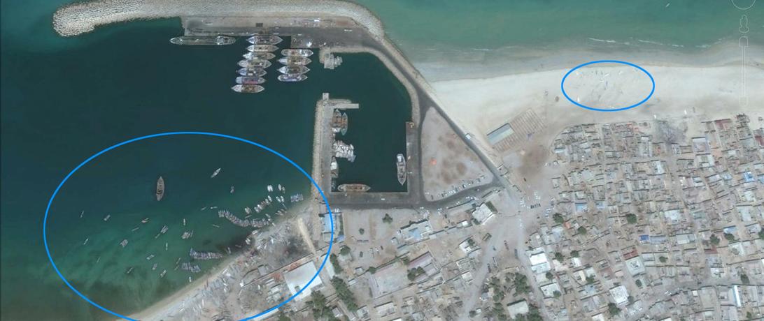
Over the last few years, the resolution of images provided to the public by Google and Bing has improved dramatically. In fact, it is now possible to clearly locate and identify artisanal fishing vessels, some just 5 meters long, on a Somali beach. Using high-resolution, easily accessible, and free satellite imagery, Secure Fisheries produced the first comprehensive map of Somali artisanal fish landing sites, complete with estimates of their size, by simply scanning images of the shoreline and counting visible boats. (Check out the end of this blog to learn how we did it).
This approach will not work everywhere, especially in places with heavily vegetated shorelines. But on the Somali coast, there are few trees and the arid landscape allows for clear images of the coastline. Somali fishers often pull their boats onto the beach or anchor them close to shore. This combined with clear imagery makes it is easy to spot landing sites dotting the shore. These images of vessels offer valuable information about a fishery that otherwise has very little data.
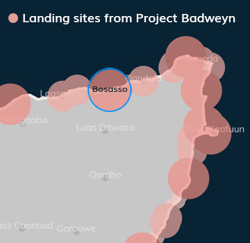 How is this information useful? Take our new effort, Project Badweyn: Mapping Somali Coastal Resources. One of the project goals is to use publicly available information, including satellite imagery, to improve understanding of the interactions between coastal resources (like fish) and the humans who utilize them (like Somali fishers). Project Badweyn provides a platform to display this new research to interested stakeholders, including coastal resource managers and the development and investment communities looking for new places to make an impact. Identifying concentrations of fishing activity is the first step toward managing coastal resources to the benefit of artisanal fishers.
Somali maritime industries are growing, especially in fishing and shipping. Predicting where competition for space may happen is crucial to creating holistic development plans that will maximize sustainable growth for both the fishing and shipping industries, while avoiding conflicts. For example, our map of landing sites shows that there are large landing areas near the largest cities. This is not surprising, but new information can be gleaned. For example, the proposed expansion of the port in Bosasso might encroach on an active landing site. Port developers can use the landing site map in Project Badweyn to see where they might expand without impacting the livelihoods of local fishers.
Satellite imagery is an increasingly important tool for understanding the global fishing industry. As the technology captures a larger portion of our Earth and at smaller time intervals, we can increase our understanding of fisheries dynamics to inform sustainable management. It does not take a super computer, or a PhD in programming, or millions of dollars. It just takes diligence, a worthwhile research question, and a little mapping know-how. Here’s how we did it:
- Acquire QGIS, a free and open source Geographic Information System software program at www.qgis.org. Download the plugins for Bing and Google imagery.
- Zoom in to a scale of approximately 1:2000 and click and drag to scan the coastline.
- Mark boats with a point on the map to record latitude and longitude coordinates.
- Obtain the date of the imagery by loading the sites into Google Earth and zooming in to each location until the date of the image is visible. For Bing images, the date of the image can be found by going to each location on the Bing Aerial Imagery Analyzer for OpenStreetMap (http://mvexel.dev.openstreetmap.org/bing/).
Go forth and map boats!