
In 2020 and 2021, new construction work was observed in the Democratic People's Republic of Korea (DPRK) near the Chamjin missile factory and the site of the suspected uranium enrichment facility in Kangson. The Chamjin missile factory is one of the key factories of the DPRK's defence sector and has been involved in the development and production of shortand medium-range ballistic missiles and intercontinental ballistic missiles (ICBMs). The nearby site referred to as Kangson is suspected to be the location of an undeclared centrifuge enrichment facility. Both sites are located in the South Pyongan Province and in an area protected by air defence systems. While the relationship between the two sites is not immediately clear, the construction work appears to be related to activities in underground facilities near the two sites. This report analyses the observed activities using available open-source information and assesses the implications for the DPRK's military policy.
Summary of Findings
Construction work has been observed near the missile factory in Chamjin-ri (hereafter referred to as the Chamjin missile factory) and the site of a suspected uranium enrichment facility in Kangson, since 2020 and in 2021, respectively. The two sites are located approximately 3.3 kilometres from each other. Both sites are located in an area protected by air defence systems. The Chamjin missile factory is one of the key factories of the DPRK's defence sector and has been involved in the development and production of short- and medium-range ballistic missiles and intercontinental ballistic missiles (ICBMs). While the relationship between the two sites is not immediately clear, the observed construction work appears to be related to underground activities near the two sites.
From February through May 2020, construction was undertaken at and near Mount Paegyang, which is located immediately north of the Chamjin missile factory. In the course of these activities, the road network was improved and modernized. The surfaces of the roads were hardened and each road was widened. The hardened and widened roads are likely able to accommodate large, heavy vehicles, such as trucks and transporter erector launchers (TELs) for missiles, so that these vehicles can move between Mount Paegyang and a highway nearby which leads to Pyongyang and Nampo. These mountain roads are connected to at least two known entrances to underground facilities on the northeast side of the mountain. The construction work may have also involved the creation of new entrances to underground facilities, and/or the hardening or renovation of existing entrances. Available satellite imagery shows that the construction work appeared to be ongoing as of 20 July 2021, and likely as late as 17 November 2021.
The suspected uranium enrichment site at Kangson is located adjacent to a hill where at least one entrance to an underground facility or tunnel has been confirmed to exist (see Section III, Figures 11-15). The hill and its surrounding area are protected by air defence systems. Between March and 17 November 2021, four new buildings were constructed near the hill. While the purposes of the buildings are unknown, three of the four buildings are located on the east side of the hill, close to the entrance to the underground facility or tunnel, and may be related to activities inside the underground facility or tunnel. This entrance is camouflaged by surrounding trees and soil. These three new buildings are located in such a way as to control access from the adjacent road to the entrance. The construction of the three new buildings on the east side of the hill, together with additional measures for camouflage and security of the entrance, and the fact that the hill is also protected by anti-aircraft guns, suggest that the activities carried out at this location are of strategic importance to the DPRK. The other new building, which is located on the west side of the hill, may also have been providing support for the activities of the workers on or near the hill or at the anti-aircraft gun sites nearby (see Section III, Figures 18 and 19).
While further examination is necessary to ascertain the purpose of the construction activities, the activities suggest ongoing development and maintenance of the strategic key site surrounding the Chamjin and Kangson complexes. In particular, the construction work on and near Mount Paegyang is consistent with the DPRK's goal to modernize the defence infrastructure as decided during the 8th Party Congress of the Workers' Party of Korea in January 2021. [1]
Geographic Information
The Chamjin missile factory (also referred to as the "Thaesong Machine Plant", the "Thaesong Machine Factory" and the "Chamjin complex") [2] is one of the DPRK's key missile factories. It is located between the cities of Pyongyang and Nampo, approximately 15 km southwest of Pyongyang and approximately 29 km northeast of Nampo (where the country's largest port is located). A suspected uranium enrichment site at Kangson (hereafter referred to as the Kangson complex) [3] is located approximately 3.3 km east of the Chamjin missile factory (Figure 1). The Chamjin and Kangson complexes are located in an area protected by anti-aircraft guns. Approximately 1 km south of the Chamjin missile factory is the Chollima steel mill complex, one of the DPRK's key suppliers of steel products for the civilian and military sectors.
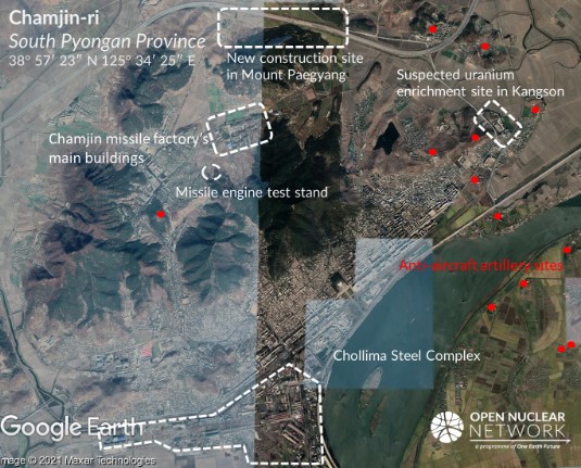
Figure 1. Locations of the Chamjin missile factory and the suspected uranium enrichment site in Kangson. Image: Google Earth © 2021 Maxar Technologies dated 9 November 2019 (left and middle) and 2 October 2020 (right)
Construction Activities Near the Chamjin Missile Factory
Background
According to a report by the United Nations Panel of Experts, [4] the Chamjin missile factory was used for testing "heat-resisting materials" for the nose cone of an intercontinental ballistic missile (ICBM) in March 2016, and for manufacturing short- and medium-range ballistic missiles, including Scud, Nodong and Musudan ballistic missiles (Figure 2).
The Chamjin missile factory is protected by anti-aircraft artillery systems and surrounded by mountains, which may suggest that the factory is of strategic importance to the DPRK.
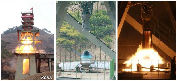
Figure 2. An engine test related to ICBM missiles at the Chamjin missile factory in March 2016 (see location in Figure 1). Images: KCNA (left) and Rodong Sinmun (right and middle). [5]
Underground Facilities in Mount Paegyang
One of the five mountains surrounding the Chamjin missile factory is Mount Paegyang, which is located immediately north of the factory and connected to a nearby highway by
roads (Figure 1). Experts have identified several entrances to probable underground facilities which support the activities of the Chamjin missile factory (Figure 3). [6]
Reportedly, the underground facilities have been used for the assembly of weapon systems and ballistic missiles. [7]
In November 2008, a Myanmar military delegation visited a missile production factory in "a suburb of Pyongyang" which is believed to refer to the Chamjin missile factory. [8] During the visit, the Myanmar delegation was able to visit and observe the production site inside an "underground tunnel". [9] After this visit, the Myanmar delegation produced an internal report about its visit and a photo booklet showing the Myanmar delegation was present in the DPRK.
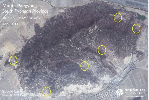
Figure 3. Locations of the entrances to underground facilities identified by Joseph S. Bermudez in May 2011. Bermudez observed, "Located immediately north of the Tae-sung Machine Factory Paegyang-san has at least six entrances to underground facilities. The two identified here are the largest and are most likely associated with the Tae-sung Machine Factory." [10] Image: Google Earth © 2021 Maxar Technologies
Subsequently, both documents were leaked to the public by The Irrawaddy, a news website of the Irrawaddy Publishing Group, which is run by a group of Burmese journalists living in exile in Thailand. [11]
According to the leaked report, the "underground tunnel" was used to house production lines for "components" of Scud missiles and conventional weapon systems, including anti-aircraft artillery, anti-tank laser-guided missiles and radar and jamming equipment. Engine assembly and final assembly of the Scud missiles were reportedly carried out at a production site on the grounds. According to the report, the tunnel was located 100 metres underground and designed to offer protection against nuclear, biological or chemical weapons attacks. [12]
Construction Work at Mount Paegyang
Between February and May 2020, construction activities were undertaken on and near the north side of Mount Paegyang. These activities were possibly aimed at improving and modernizing the mountain road network for the Chamjin missile factory. The activities may also have involved the construction of new entrances to the underground facilities or the hardening or renovation of existing entrances.
Satellite imagery shows that sometime between 23 and 27 February 2020, construction started on the northwest side of the mountain. By 2 May 2020, the surfaces of the mountain roads had been hardened, and each road was widened to about 5 to 7 metres. Similarly, the surfaces of the roads extending from the mountain's edge to the nearby highway leading to the cities of Pyongyang and Nampo (known as the "Youth Hero Highway") were hardened (Figures 4 and 5). Through satellite imagery analysis, the estimated total length of the improved roads is calculated as being approximately 5.14 km (Figure 6).
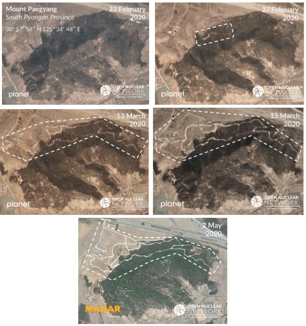
Figure 4. Construction work on and near Mount Paegyang, 23 February – 2 May 2020. Images: © 2021 Planet Labs Inc. (top four) and Maxar Technologies (bottom). All Rights Reserved. Reprinted by permission
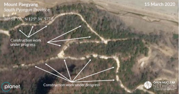
Figure 5. Construction work under progress as of 15 March 2020. Image © 2021 Planet Labs Inc. All Rights Reserved. Reprinted by permission
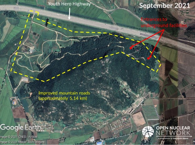
Figure 6. Overview of the improved road network. Image: Google Earth © 2021 CNES / Airbus, © 2021 Maxar Technologies
The hardened and widened roads are likely able to accommodate large heavy vehicles, such as trucks and transporter erector launchers (TELs) for missiles, so that these vehicles can move between the mountain and the Youth Hero Highway (Figure 6). These roads are connected to at least two known underground entrances on the northeast side of the mountain (Figure 6).
Along the improved mountain roads, there are at least eight segments where the roads appear to be widened (marked in white circles in Figure 7). Hardened flat structures are visible on the roadsides of some of these sections. In one segment that stretches from a dent on the roadside, a trace of possible vehicular traffic is visible. An entrance to the underground facility might exist at some of these locations.
Some of the intersections of the improved mountain roads are approximately 15 metres wide, sufficient to accommodate traffic of large, heavy vehicles.
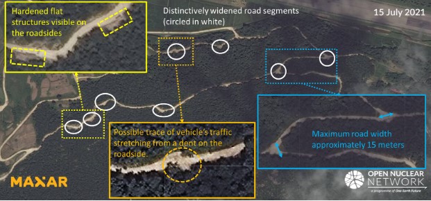
Figure 7. Widened segments along the improved mountain roads on Mount Paegyang. Image: © 2021 Maxar Technologies. All Rights Reserved. Reprinted by permission
Satellite imagery shows that, as of 20 July 2021, soil had accumulated on the road surfaces, in particular near the widened segments and the intersections. There appeared to be ongoing construction near these locations, possibly related to the construction or renovation of the underground facilities because no structures were visible on the mountain surface nearby (Figure 8). Available satellite imagery also shows that the road pavement work near the northeast side of the mountain was suspended after May 2020 and likely
remained unfinished as of 17 November 2021, as suggested by the existence of unpaved parts of the road (Figure 9).
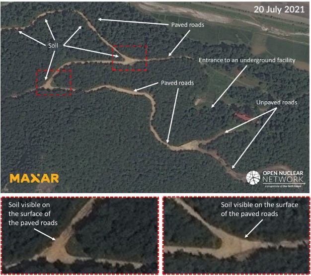
Figure 8. Construction work on Mount Paegyang as early as 20 July 2021. The two images at the bottom show close-ups of the two areas marked in the red squares in the image above. Images: © 2021 Maxar Technologies. All Rights Reserved. Reprinted by permission
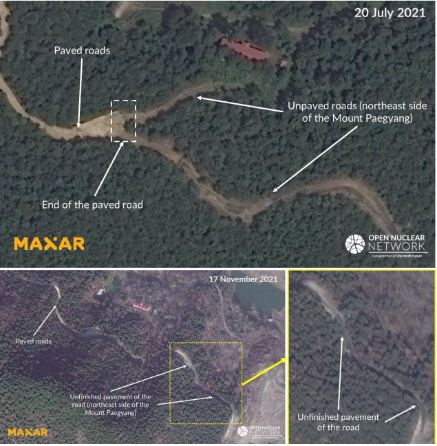
Figure 9. Unpaved roads on the northeast side of Mount Paegyang as of 20 July and 17 November 2021. Images: © 2021 Maxar Technologies. All Rights Reserved. Reprinted by permission
Construction work was also observed on top of a hill located immediately southwest of Mount Paegyang. [13] Sometime between June and 8 September 2020, the top of the hill was flattened, and a new flatbed structure was created. Four tall objects were installed on the flatbed structure (Figure 10). The purpose of this structure is unclear.
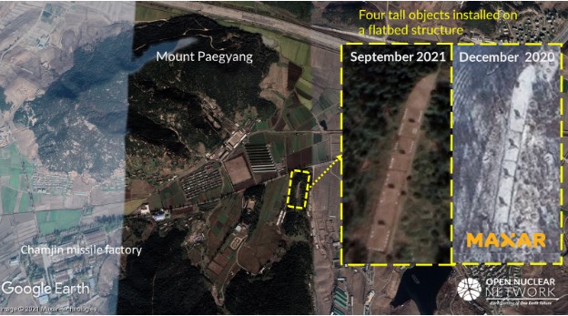
Figure 10. New flatbed structure created near Mount Paegyang. Image: Google Earth © 2021 Maxar Technologies (base image, insert image left), © 2021 Maxar
Technologies (insert image right). All Rights Reserved. Reprinted by permission
Construction Activities Near Suspected Uranium Enrichment Site in Kangson
The site of the suspected uranium enrichment facility at Kangson is located approximately 3.3 km east of the Chamjin missile factory. The Kangson complex and its surrounding area are protected by multiple anti-aircraft artillery sites, which suggests that this area is of strategic importance to the DPRK (Figure 11).
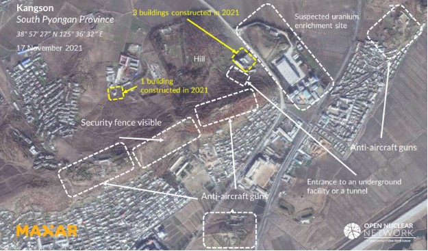
Figure 11. Overview of the area near the Kangson complex. Image: © 2021 Maxar Technologies. All Rights Reserved. Reprinted by permission
As indicated in Figure 12, a hill is located across the road from the suspected uranium enrichment site. In 2021, four new buildings were constructed near this hill: three on the east side of the hill and the fourth on the west side.
The three new buildings on the east side of the hill were constructed in front of an entrance to an underground facility or tunnel which was visible as of November 2020 (Figure 12). Satellite imagery shows that, at some point between 9 June and 30 July 2020, construction of the first (and largest) of the three buildings was initiated in front of this entrance, and that the construction of all three of the buildings was completed sometime between July and 17 November 2021.
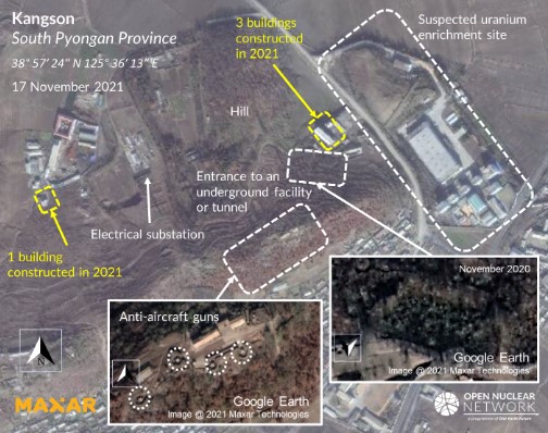
Figure 12. The four new buildings near the suspected uranium enrichment site are indicated in yellow. Images: Google Earth © 2021 Maxar Technologies (insert images), © 2021 Maxar Technologies. All Rights Reserved. Reprinted by permission
Available satellite imagery shows that the largest of the three buildings on the east side of the hill is two or three stories high. While the purpose of these three new buildings is unknown, they may be related to the activities inside the underground facility or tunnel given its proximity to the entrance (Figure 13). If this observation is correct, the construction of these buildings would indicate increased activity inside the underground facility or tunnel. In addition, the buildings are located in such a way as to control access from the adjacent road to the entrance and can provide security for the entrance (Figure 14). The entrance is camouflaged by the surrounding trees and soil; during the summer it was covered by a grove of trees and was completely concealed (Figure 13). The construction of the three new buildings, together with additional measures for camouflage and security at the entrance, and the fact that the hill is protected by anti-aircraft guns suggest that this location is of strategic importance to the DPRK.
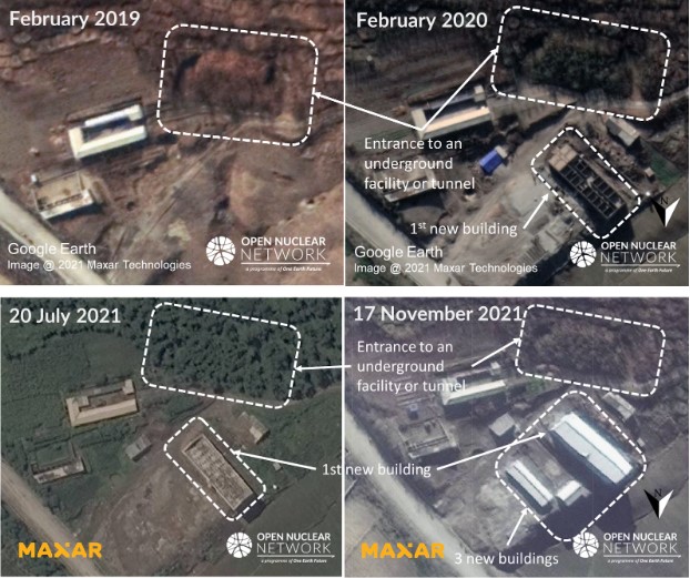
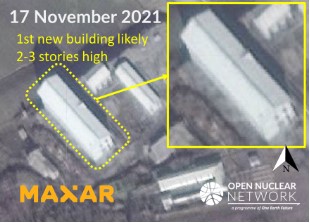
Figure 13. Three new buildings on the east side of the hill in 2021, including the first new building likely 2-3 stories high. Images: Google Earth (two images on top), © 2021 Maxar Technologies (three images on bottom). All Rights Reserved. Reprinted by permission
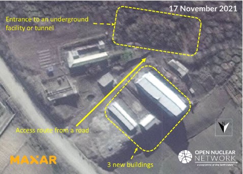
Figure 14. Locations of the new buildings on the east side of the hill and the entrance to the underground facility or tunnel. Image: Google Earth (dated 9 November 2020) © 2021 Maxar Technologies
At some point between 2 March and 20 July 2021, a fourth new building was constructed on the west side of the hill adjacent to a complex of buildings (Figures 12 and 15). This building complex comprises a main building, a square-shaped building, green houses or agriculture-related structures and a parking space for trucks.
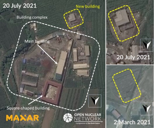
Figure 15. New building on the west of the hill. Image: © 2021 Maxar Technologies. All Rights Reserved. Reprinted by permission
While the purposes of the building complex and the adjacent new building are not immediately clear, as described below, available satellite imagery shows that the complex may have been used to support activities for personnel on or near the hill.
The building complex and the hill are co-located with two anti-aircraft gun sites (circled in orange in Figure 16). The southside of this area is separated by security perimeter fences from the other buildings on the south. Although it is unclear whether the entire area circled in orange in Figure 16 is under guard, the presence of anti-aircraft guns and the security perimeter fences on the south suggest that this area may be sensitive and access is restricted.
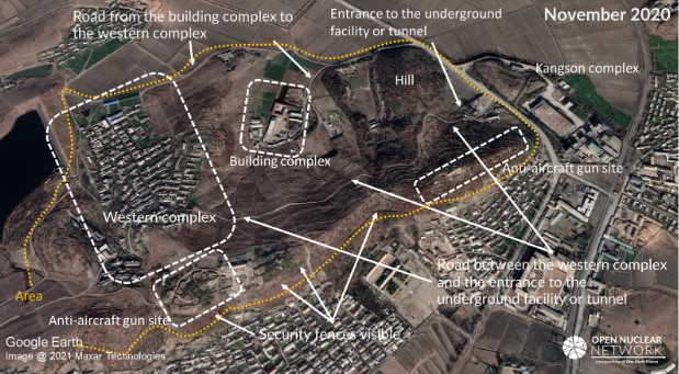
Figure 16. Overview of the compartment (marked in orange circle). Image: Google Earth © 2021 Maxar Technologies
Immediately west of the complex is another building complex which appears to be a residential area (hereafter referred to as "the western complex"). The western complex is in the vicinity of an anti-aircraft gun site and is also connected by a road to the other anti-aircraft gun site. This road stretches further to the east, passes over the hill and leads to the entrance of the underground facility or tunnel. The road network suggests that people commute from the western complex to the hill or to the two anti-aircraft gun sites, indicating that the activities inside this area are linked.
Given that the building complex is located between the hill and the western complex where access could be restricted, and the building complex is also connected by roads to these two sites, the building complex is likely related to activities carried out inside this area.
Satellite imagery shows that, inside the complex, the main building and the square-shaped building were constructed at some time between September 2015 and January 2017. Since then, multiple trucks and piles of soil - and what might be fertilizer given the presence of greenhouses - were observed on the premises and in the adjacent yard (Figure 17). The trucks and piles of soils indicate that the complex could be related to construction or excavation; the presence of the trucks, soil, greenhouses and possible fertilizer indicate that the building complex could also be related to agricultural activities. As is the case at other facilities in the DPRK, people in this building complex appear to have been growing their own vegetables and crops for subsistence. During the harvesting season, the premises of the building complex have also been used for the harvesting and storage of crops (Figure 17).
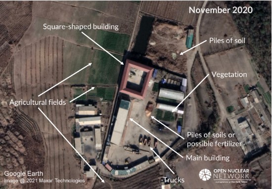
Figure 17. Building complex. Image: Google Earth © 2021 Maxar Technologies
Implications
While further examination is necessary to ascertain the purpose of the construction, these activities suggest ongoing development and maintenance of the area surrounding the Chamjin and Kangson complexes. In particular, the construction work on and near Mount Paegyang is consistent with the DPRK's goal to modernize the defence infrastructure, as decided during the 8th Party Congress of the Workers' Party of Korea in January 2021. [14]
In addition, the construction of the four new buildings near the Kangson complex warrants further scrutiny. While the purposes of these new buildings are not immediately clear, they may be intended to support the activities carried out in the underground facility or tunnel and the anti-aircraft gun sites near the Kangson complex and the personnel working at these sites.
ONN will continue to monitor developments at these complexes.
[1] Great Programme for Struggle Leading Korean-style Socialist Construction to Fresh Victory: On Report Made by Supreme Leader Kim Jong Un at Eighth Congress of WPK, Rodong Sinmun, 10 January 2021
[2] Geographical coordinate: 38° 57′ 23′′ N, 125° 34′ 28′′ E
[3] IAEA, GOV/2018/34-GC(62)/12, para. 22; GOV/2020/42–GC(64)/18, para. 14; GOV/2021/40-GC(65)/22, para. 14
[4] The United Nations, S/2017/150, p. 45, available at: https://www.securitycouncilreport.org/atf/cf/%7B65BFCF9B-6D27-4E9C-8CD3-CF6E4FF96FF9%7D/s_2017_150.pdf. See also Kim Jong Un guides ballistic rocket's re-entry environmental simulation, Rodong Sinmun, 15 March 2016
[5] Kim Jong Un Guides Ballistic Rocket's Reentry Environmental Simulation, Rodong Sinmun, 15 March 2016; Kim Jong Un Guides Ballistic Rocket's Reentry Environmental Simulation, KCNA, 15 March 2016
[6] In 2011, Joseph S. Bermudez Jr., Senior Fellow for Imagery Analysis at the Center for Strategic and International Security, identified at least six entrances to underground facilities. Bermudez assessed that at least two of the six entrances were most likely associated with the factory given their proximity to some of the factory's buildings. See, Joseph S. Bermudez Jr., KPA Journal, Vol. 2, No. 5, May 2011, available at: http://static1.1.sqspcdn.com/static/f/716134/13620249/1313028417477/KPAJ-2-05.pdf
[7] Joseph S. Bermudez Jr., KPA Journal, Vol. 2, No. 5, May 2011, available at: http://static1.1.sqspcdn.com/static/f/716134/13620249/1313028417477/KPAJ-2-05.pdf
[8] Joseph S. Bermudez Jr., KPA Journal, Vol. 2, No. 5, May 2011, available at: http://static1.1.sqspcdn.com/static/f/716134/13620249/1313028417477/KPAJ-2-05.pdf. As of 2010, the Chamjin missile factory was the only known underground facility associated with missile production and located near Pyongyang.
[9] Aung Zaw, Burma's Secret Mission to North Korea, The Irrawaddy, July 2009, available at: https://www2.irrawaddy.com/article.php?art_id=16219; ြ န်မာ့တပ်မေတာ် မ အဆင့်မြ င့်ကိုယ်စားလှယ်အဖွဲ၏ အစီရင်ခံစာ [Report of the Myanmar Armed Forces High Level Delegation], The Irrawaddy, 10 June 2010, available at: https://web.archive.org/web/20100612141520/http://www.irrawaddy.org/Burma_NKorea_report.pdf
[10] Joseph S. Bermudez Jr., KPA Journal, Vol. 2, No. 5, May 2011, available at: http://static1.1.sqspcdn.com/static/f/716134/13620249/1313028417477/KPAJ-2-05.pdf
[11] Aung Zaw, Burma's Secret Mission to North Korea, The Irrawaddy, July 2009, available at: https://www2.irrawaddy.com/article.php?art_id=16219; ြ န်မာ့တပ်မေတာ် မ အဆင့်မြ င့်ကိုယ်စားလှယ်အဖွဲ၏ အစီရင်ခံစာ [Report of the Myanmar Armed Forces High Level Delegation], The Irrawaddy, 10 June 2010, available at: https://web.archive.org/web/20100612141520/http://www.irrawaddy.org/Burma_NKorea_report.pdf
[12] Aung Zaw, Burma's Secret Mission to North Korea, The Irrawaddy, July 2009, available at: https://www2.irrawaddy.com/article.php?art_id=16219; ြ န်မာ့တပ်မေတာ် မ အဆင့်မြ င့်ကိုယ်စားလှယ်အဖွဲ၏ အစီရင်ခံစာ [Report of the Myanmar Armed Forces High Level Delegation], The Irrawaddy, 10 June 2010, available at: https://web.archive.org/web/20100612141520/http://www.irrawaddy.org/Burma_NKorea_report.pdf
[13] Geographic coordinates: 38° 57' 35", 125° 35' 16"
[14] Great Programme for Struggle Leading Korean-style Socialist Construction to Fresh Victory: On Report Made by Supreme Leader Kim Jong Un at Eighth Congress of WPK, Rodong Sinmun, 10 January 2021