
In August 2021, the Democratic People's Republic of Korea (DPRK) experienced heavy rainfall and severe flooding. ONN has analysed available open-source information and identified locations of possible damage and assessed the scope of such damage. This paper provides a summary of ONN's findings.
Key Findings
From 1 to 3 August 2021, multiple cities and counties in North Hamgyong Province and South Hamgyong Province in the DPRK were affected by heavy rainfall which recorded precipitation levels that far exceeded historical averages. Reportedly, the heavy rainfall and flooding affected houses, roads, bridges and agricultural fields in the region. The scale of the reported damage this year appears to be as extensive as the damage highlighted in DPRK media in August 2020.
For most of the subsequent days in August, heavy rainfall occurred in various regions throughout the country, which appears to have caused additional damage to these two provinces as well as damage to other provinces not reported in DPRK media.
In order to assess the impact of the heavy rainfall and flooding on the DPRK in August 2021, ONN gathered and analysed information from DPRK media and satellite imagery, as well as data from monitoring stations in or near the DPRK.
ONN's findings are summarized below:
-
The extensive damage to building/housing areas, roads, bridges and riversides in North Hamgyong Province and South Hamgyong Province, as reported in DPRK media, can be confirmed through satellite imagery. Although they were not mentioned in DPRK media, other provinces were also adversely impacted.
-
According to DPRK media reports, several square kilometres of agricultural fields in South Hamgyong Province were flooded, while 17 km of roads, 8.1 km of embankment and multiple bridges were damaged. Based on available satellite imagery, ONN has confirmed that, at a minimum, approximately 3.7 km2 of agricultural fields and approximately 6.8 km-long roads and embankments were affected in or near Sinhung County and Yonggwang County in South Hamgyong Province, the most heavily damaged areas in the DPRK due to the heavy rainfall and flooding in early August. While the full extent of the damage is not yet precisely known, the scale of the affected areas suggests that the damage may have a significant impact on crops in the coming weeks.
-
DPRK media has also reported that the heavy rainfall and flooding appear to have created damage in North Hamgyong Province. The affected areas include the Komusan area in North Hamgyong Province where the Komusan Cement Factory is located. According to a DPRK media report, this factory is equipped with "a high-quality refractory workshop" and has served as one of the key producers of cement products in North Hamgyong Province. Satellite imagery shows that the railways used by this factory were flooded and possibly damaged. Prolonged damage to these railways could constrain the local capacity to produce and supply cement products to reconstruction sites in affected areas.
-
Water levels have risen significantly at dams and water reservoirs, recovering from the reduced levels caused by the drought in July. Although there are signs of possible overflow of water at some of the reservoirs, there are no visible signs of damage to these dams or reservoirs.
-
No damage could be observed at most facilities known to be related to the DPRK's nuclear or ballistic missile programmes, with the exception of the Tonghae Satellite Launching Ground where some of the buildings were flooded. However, it is unclear whether these buildings were damaged.
-
The precipitation levels in August reported by monitoring stations in and near the DPRK indicate several unusual spikes that are many times higher than historical averages, particularly on and around 10 and 21 August. As of 31 August 2021, the monsoon season had not yet concluded in the DPRK. A prolonged period of heavy rainfall and flooding could further weaken the soil, which could cause further damage to roads, railways, riversides and agricultural areas. To prevent additional damage, further measures would be needed for the DPRK to ensure the integrity of these structures and locations.
-
Some regions in the DPRK experienced only low levels of precipitation in August, including Pyonggang County in Kangwon Province, where a drought has been continuing since midJuly.
In summary, the DPRK has suffered from extreme weather conditions - both heavy rainfall and drought - some of which continue to prevail. The extreme weather conditions are expected to impose significant economic and social costs on the DPRK.
Introduction
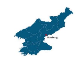
On 5 August 2021, Korean Central Television (KCTV) reported that multiple cities and counties in North Hamgyong Province and South Hamgyong Province (Figure 1) experienced heavy rainfall with precipitation levels significantly greater than historical averages. Damage reportedly occurred to houses, roads, bridges and agricultural fields in the region. [1]
Heavy rainfall continued to occur throughout the rest of August in various regions in the country, which appears to have caused additional damage to these two provinces as well as damage to other provinces not explicitly reported in DPRK media.
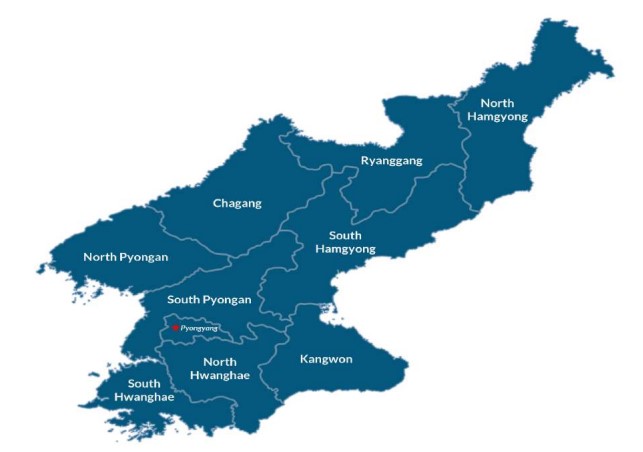
Figure 1. Map of the DPRK. Shapefile source: UN Office for the Coordination of Humanitarian Affairs
Precipitation in August 2021
From mid to late July 2021, the DPRK experienced widespread drought. For most regions in the country, however, this was followed by heavy rainfall in August. [2] Although North Hamgyong Province and South Hamgyong Province were not the only regions which experienced heavy rainfall in August, they appear to have been the most significantly affected, which could explain why DPRK media reports focussed on those two provinces.
The precipitation levels for August reported by 19 DPRK monitoring stations and four Chinese monitoring stations near the border with the DPRK [3] recorded unusual spikes far higher than historical averages, [4] in particular on or around three specific periods (1-3 August, 10-13 August and 21 August), as can be seen in Figures 2.a through 2.d below. Most of these spikes also exceeded those recorded during the same time period in 2020.
On the other hand, some regions experienced low precipitation, including Pyonggang County in Kangwon Province, which has been suffering from drought since mid-July. Overall, many regions of the DPRK appear to have experienced extreme weather conditions, whether continuing drought or heavy rainfall.
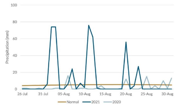
Figure 2.a. Precipitation at Chongjin, North Hamgyong Province. Source: World Meteorological Organization
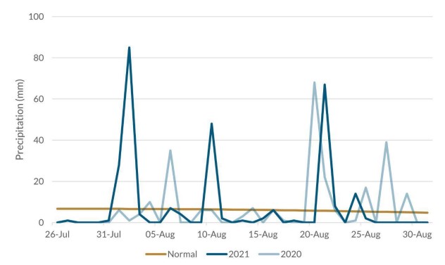
Figure 2.b. Precipitation at Pungsan, Ryanggang Province. Source: World Meteorological Organization
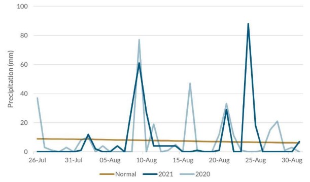
Figure 2.c. Precipitation at Wonsan, Kangwon Province. Source: World Meteorological Organization
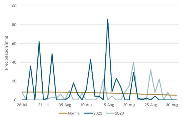
Figure 2.d. Precipitation at Kanggye, Chagang Province. Source: World Meteorological Organization
Damage Reported by DPRK Media
DPRK Media Reporting in August 2021
According to KCTV, Puryong County in North Hamgyong Province experienced the greatest volume of rainfall in the DPRK and recorded the highest precipitation level of 583 mm between 1 and 3 August 2021. Sinhung County in South Hamgyong Province recorded the second highest precipitation level of 308 mm for the same period (Figure 3). [5]
Other areas of these two provinces were also affected, including Hamhung, Hochon County, Pujon County, Pukchong County and Rakwon County and Tanchon in South Hamgyong Province, and Kilju County in North Hamgyong Province, which recorded precipitation levels between 158 and 202 mm for the same period (Figure 3).
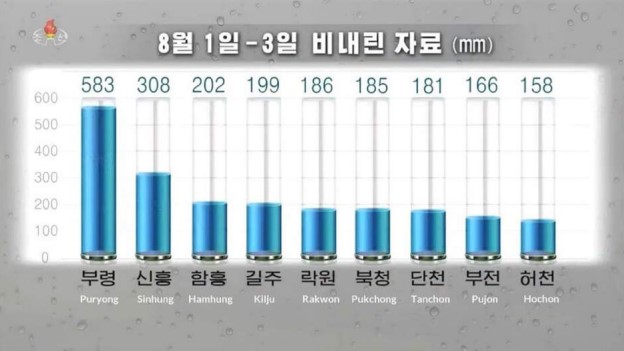
Figure 3. Highest precipitation levels in cities and counties in South and North Hamgyong Province, 1-3 August 2021. Source: KCTV
KCTV aired video footage showing extensive damage to South Hamgyong Province caused by heavy rainfall and severe flooding, in particular, to houses, roads, bridges and agricultural fields (Figure 4). Subsequent reporting by Rodong Sinmun and Korea Central News Agency (KCNA) identified damage to other areas in the South and North Hamgyong Provinces, including Hongwon County and Yonggwang County in South Hamgyong Province and Puryong County in North Hamgyong Province. [6]
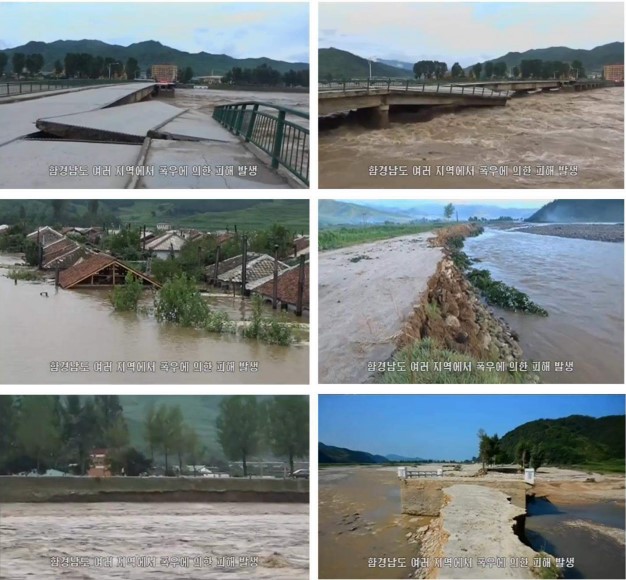
Figure 4. Damage due to heavy rainfall and flooding between 1 and 3 August 2021 in South Hamgyong Province. The caption in the Korean script states, "Numerous areas in South Hamgyong Province were damaged by the rainstorms." Source: KCTV [7]
Comparison of Reported Damage in August 2020 and August 2021
Figure 5 below compares the damage due to heavy rainfall and flooding in South Hamgyong Province in early August 2021, as reported by DPRK media, with the damage reported in August 2020 for Unpha County in North Hwanghae Province, which was likely the most significantly affected area in the DPRK at that time.
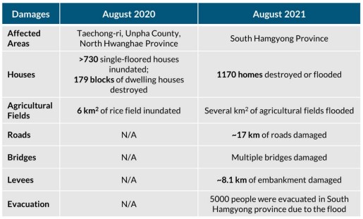
Figure 5. Comparison of reported damage from heavy rainfall and flooding in August 2020 and August 2021. Source: KCNA and KCTV [8]
While the scale of the reported damage is difficult to compare due to a lack of available common data points, the damage reported in August 2021 appears to be of a scale similar to that reported in August 2020.
According to KCTV, in early August 2021, nearly 17 km of roads and multiple bridges were damaged. In addition, about 8.1 km of embankments were damaged, which resulted in the flooding over several square kilometres of agricultural fields. In August 2020, DPRK media did not report the number of roads, bridges or embankments affected by flooding, but did report that 6 km2 of rice fields had been inundated.
In August 2020, DPRK media reported that approximately 730 single-floored houses were inundated and 179 blocks of dwelling houses were destroyed, as compared with the 1170 homes reported to have been destroyed or flooded in early August 2021. DPRK media reported that 5,000 people were forced to evacuate the affected areas in August 2021. No comparable data was reported for August 2020.
ONN has confirmed through satellite imagery analysis that, at a minimum, approximately 3.7 km2 of agricultural fields and approximately 6.8 km of roads and embankments along rivers had been affected in and near Sinhung County and Yonggwang County, the most heavily damaged area in the DPRK in early August.
The heavy rainfall and flooding in 2020 had already caused considerable damage to the harvest and food supply in 2021. This was acknowledged by Kim Jong Un in his speech on 15 June 2021 during the 3rd Plenary Meeting of the 8th Central Committee of the Workers' Party of Korea, in which he stated that "the people's food situation is now getting tense as the agricultural sector failed to fulfill its grain production plan due to the damage by typhoon last year". [9] While the full extent of the damage as a result of the August 2021 rainfall and flooding is not yet precisely known, the scale of the areas affected suggests that the damage will likely negatively impact agricultural crops in the coming weeks. Extensive damage to the agricultural fields in 2021 could further destabilize the DPRK's efforts to ensure a stable supply of food.
Assessment of Damage
ONN has analysed satellite imagery from August 2021 of the estuaries throughout the DPRK in search of signatures of heavy rainfall and flooding, [10] and has identified the following areas as having been the most significantly affected by the heavy rainfall and flooding in August in the DPRK:
1. Hamhung in South Hamgyong Province;
2. Areas between Yonggwang County and Sinhung County in South Hamgyong Province;
3. Sinhung County in South Hamgyong Province; and
4. Komusan in Puryong County, North Hamgyong Province.
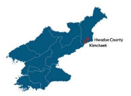
ONN also identified possible damage in the following areas in North Hamgyong Province, albeit with a medium confidence level due to a limitation on the availability of high-resolution satellite imagery: Hwadae County; an area at the administrative border between Hwadae County and Kimchaek; and Kimchaek.
In addition to having damaged infrastructure, such as roads, embankments, houses, buildings and waterways, the heavy rainfall and flooding appear to have damaged some railways, including those used for industrial purposes. Prolonged damage to these railways could constrain the local capacity to produce and supply products needed for reconstruction efforts in the affected areas.
Water levels have risen significantly at dams and water reservoirs, recovering from the reduced levels caused by the drought in July. Although there are signs of possible overflow of water at some of the reservoirs, there are no visible signs of damage to these dams or reservoirs.
No damage could be observed at most facilities known to be related to nuclear or ballistic missile programmes except the Tonghae Satellite Launching Ground, where some of the newly constructed houses or facilities were flooded. However, it is unclear whether these structures were damaged.
Areas with Damage
Hamhung, South Hamgyong Province
DPRK media frequently referred to Hamhung as one of the areas that was significantly affected by heavy rainfall and flooding and where reconstruction activities were being undertaken. High precipitation levels in Hamhung were recorded on 1, 10 and 21 August (Figure 6).
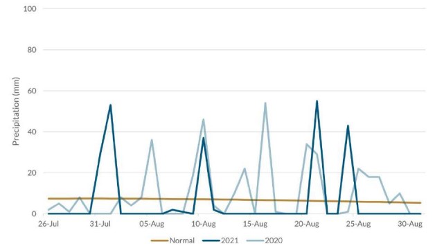
Figure 6. Precipitation at Hamhung, South Hamgyong Province. Source: World Meteorological Organization
Satellite imagery confirms extensive damage in and near Hamhung, especially in early August, including damage to bridges and roads, buildings and agricultural fields, and water overflow from a reservoir. Extensive damage can be observed in particular in areas in or near the Hoesang District of Hamhung.
On 9 August, Rodong Sinmun reported on "road restoration work" between Ssangbongri and Ryeongbong-gul in the Hoesang District. [11] Damage to multiple areas in that district can be confirmed.
Due to the heavy rainfall, a large amount of water was accumulated in a water reservoir in the district. When the water was released from the reservoir, a wide area of agricultural fields downstream was flooded. Satellite imagery shows that approximately 3.5 km of the embankment was breached and agricultural areas along the embankment were flooded.
In addition, flooding caused by heavy rainfall in several mountain ridges damaged residential areas and roads along the rivers in the valleys (Figures 7 to 9).
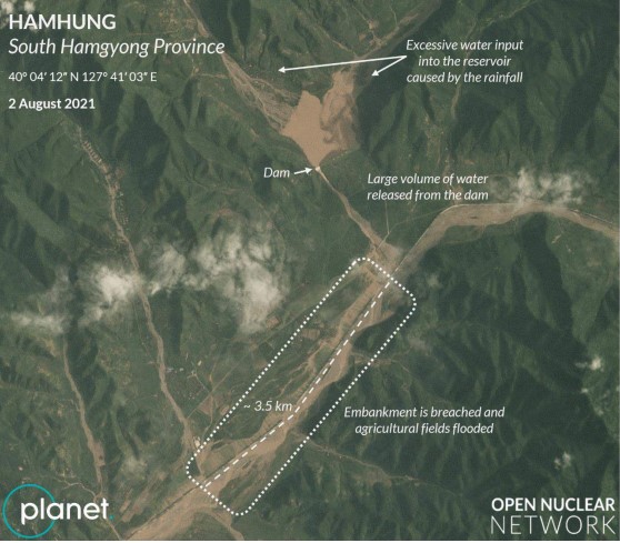
Figure 7. A large volume of water was released from a dam, which flooded the agricultural fields in the downstream area on 2 August 2021. As a result, about 3.5 km of the embankment was breached and agricultural fields were flooded. Image © 2021 Planet Labs Inc. All Rights Reserved. Reprinted by permission
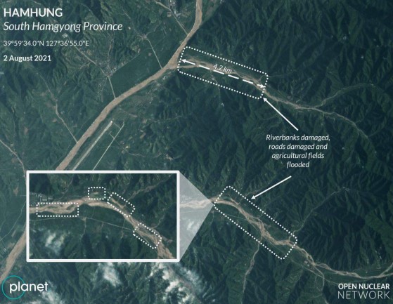
Figure 8. Along one of the other rivers, riverbanks and roads were damaged and agricultural fields were flooded (about 4.2 km) on 2 August 2021. Image © 2021 Planet Labs Inc. All Rights Reserved. Reprinted by permission
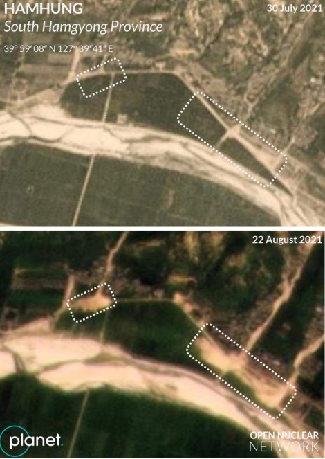
Figure 9. Agricultural fields were washed away during the flooding on 2 August 2021. Image © 2021 Planet Labs Inc. All Rights Reserved. Reprinted by permission
Areas between Yonggwang County and Sinhung County, South Hamgyong Province
On 9 August, Rodong Sinmun reported on “road restoration work” between Yonggwang County and Sinhung County in the South Hamgyong Province (Figure 10). [12]
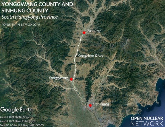
Figure 10. Sinhung County, Yonggwang County and Hamhung. Image: Google Earth
Consistent with the reporting, satellite imagery from 3 August confirms extensive damage from flooding along the Songchon River and the roads between Yonggwang County and Sinhung County, a distance of approximately 21 km (Figure 11). Available satellite imagery shows that, at a minimum, over 2.5 km2 of agricultural fields were flooded along this river. As of 22 August, several embankments had not yet been repaired and water had not yet receded from several flooded agricultural fields.
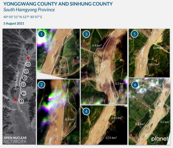
Figure 11. Damage to embankments and roads and flooding in agricultural fields along the Songchon River between Yonggwang County and Sinhung County on 3 August. Images: Google Earth and Planet Labs. Image © 2021 Planet Labs Inc. All Rights Reserved. Reprinted by permission
In addition, several waterways along the Songchon River were filled with sediment or destroyed during the flooding (Figure 12). These waterways may have been used as irrigation canals or for the purpose of supplying water to fisheries or agricultural areas. The damage to these waterways could negatively impact agricultural and fishery operations in the surrounding area.
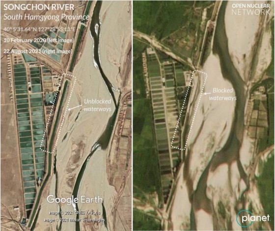
Figure 12. Example of damage to waterways along the Songchon River. Images: Google Earth and Planet Labs. Image © 2021 Planet Labs Inc. All Rights Reserved. Reprinted by permission
Sinhung County, South Hamgyong Province
Satellite imagery confirms extensive damage in and near Sinhung County, including extensive flooding in the centre of the county and two damaged bridges (Figure 13). [13]
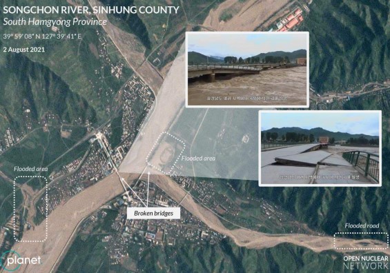
Figure 13. Examples of damage to waterways along the Songchon River and damaged bridges in Sinhung County. Source: Planet Labs and KCTV. Image © 2021 Planet Labs Inc. All Rights Reserved. Reprinted by permission
To the north of the county's centre, an approximately 1.3 km of the river embankment were damaged, and approximately 1.2 km2 of agricultural fields were flooded (Figure 14).
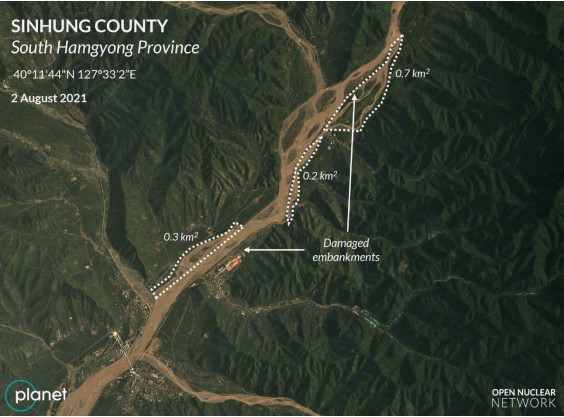
Figure 14. Flooding and damaged embankments north of the centre of Sinhung County. Image © 2021 Planet Labs Inc. All Rights Reserved. Reprinted by permission
To the east of the county's centre, an approximately 5.5 km length of a road was flooded and/or damaged, which resulted in the isolation of a town (Figure 15).
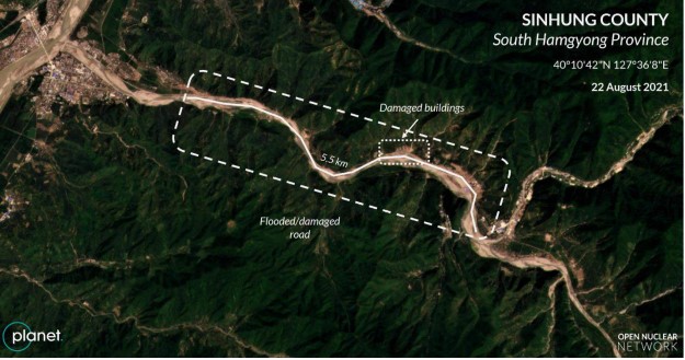
Figure 15. Flooding east of the centre of Sinhung County. Image © 2021 Planet Labs Inc. All Rights Reserved. Reprinted by permission
Along the damaged road, a residential district was almost completely washed away (Figure 16) and a number of houses or buildings also disappeared (Figures 16 and 17). [14]
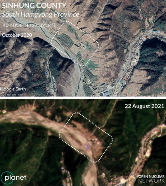
Figure 16. Residential district washed away east of Sinhung County's centre in early August. Images: Google Earth and Planet Labs. Image © 2021 Planet Labs Inc. All Rights Reserved. Reprinted by permission
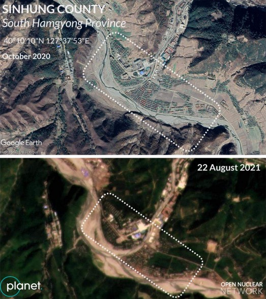
Figure 17. Houses and other buildings washed away further east of Sinhung County's centre in early August. Images: Google Earth and Planet Labs. Image © 2021 Planet Labs Inc. All Rights Reserved. Reprinted by permission
Puryong County, North Hamgyong Province
Komusan in North Hamgyong Province was also affected by the heavy rainfall and flooding (Figure 18). Noteworthy, in particular, is the damage to the Komusan Cement Factory. According to a report in DPRK media, the factory is equipped with "a high-quality refractory workshop" and has served as one of the key producers of cement products in North Hamgyong Province (Figure 18). [15] Satellite imagery from 3-4 August shows that the railways used by this factory and the Komusan train station close to the factory were flooded. Satellite imagery from 19 August shows that the railways appeared to have been still covered by sediment, indicating that the damage had not yet been repaired. Prolonged damage to these railways could constrain local capacity to produce and supply cement products to reconstruction sites in the affected areas.
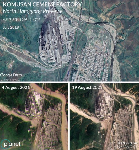
Figure 18. Satellite imagery showing flooded railways near the Komusan Cement Factory (bottom left). Traces of the damage to railways can be observed in satellite imagery from 19 August (bottom right). Images: Google Earth and Planet Labs. Image © 2021 Planet Labs Inc. All Rights Reserved. Reprinted by permission
Other Areas with Signs of Possible Damage
ONN has found other areas in the DPRK with signs of possible flooding in North Hamgyong Province, including Hwadae County, an area at the administrative border between Hwadae County and Kimchaek, as well as in Kimchaek. While clear signs of damage were hard to confirm through available satellite imagery, these areas could be further affected in the coming weeks by heavy rainfall and flooding.
Hwadae County, North Hamgyong Province
Hwadae County is located approximately 200 km northeast of Hamhung. This county was also affected by heavy rainfall and flooding at least twice in August. Satellite imagery shows that a bridge over a main road along the eastern coast of the DPRK was flooded on 3 and 22 August (Figure 19). While no clear damage to the bridge could be observed from the satellite imagery of 30 August, repeated flooding could undermine the strength of the bridge which serves as one of the key nodes in land transportation along the DPRK's eastern coast.
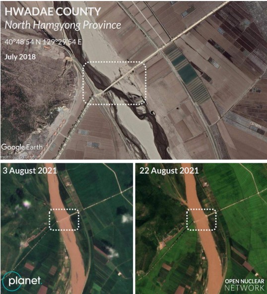
Figure 19. Repeated flooding of the bridge in Hwadae County. Images: Google Earth and Planet Labs. Image © 2021 Planet Labs Inc. All Rights Reserved. Reprinted by permission
In addition, there is a river weir approximately 8 km upstream from the flooded bridge which was almost completely flooded and possibly destroyed.
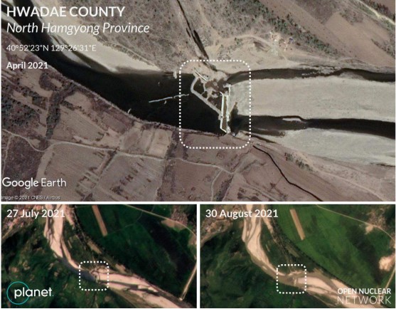
Figure 20. River weir near Hwadae County completely flooded in August. Images: Google Earth and Planet Labs. Image © 2021 Planet Labs Inc. All Rights Reserved. Reprinted by permission
Hwadae County and Kimchaek, North Hamgyong Province
A key bridge over the Namdaechon River at the administrative border between Hwadae County and Kimchaek has also been adversely impacted by the heavy rain and flooding. The bridge was already damaged sometime before 3 June 2021 and was further damaged by flooding in August. As of 30 August, the bridge had still not been repaired (Figure 21).
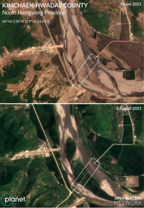
Figure 21. A damaged bridge near Chagundojang-dong. Image © 2021 Planet Labs Inc. All Rights Reserved. Reprinted by permission
The village of Kokjin-ri on the east coast of Hwadae County was also flooded in early August (Figure 22). [16] The water had not yet receded as of 3 September.
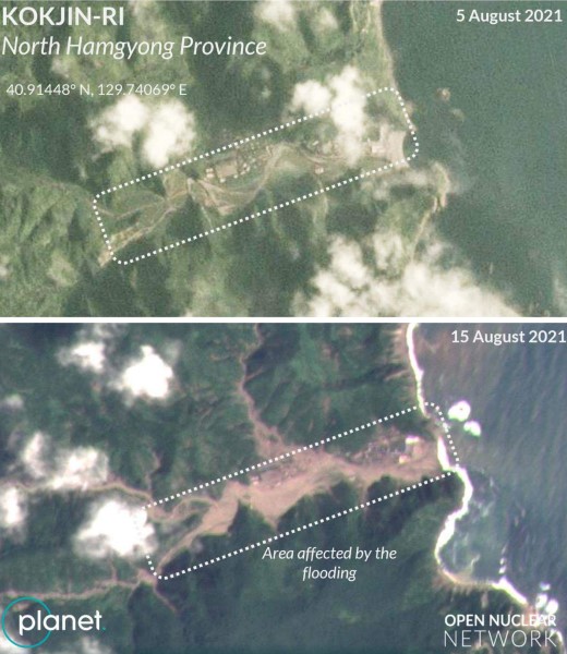
Figure 22. Satellite images from 5 August and 15 August showing flooding of Kokjin-ri on the east coast of Hwadae County. Image © 2021 Planet Labs Inc. All Rights Reserved. Reprinted by permission
Kimchaek, North Hamgyong Province
According to a KCTV report, the city of Kimchaek also experienced heavy rainfall in August. Satellite imagery from August 2021 shows that one of the key bridges in Kimchaek may have been damaged and repaired sometime between 19 and 28 August. Available satellite imagery from 22 August shows a possible sign of construction work at the bridge (Figure 23).
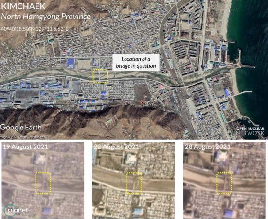
Figure 23. Overview of Kimchaek and the location of a bridge possibly damaged and then repaired in August 2021. Images: Google Earth and Planet Labs. Image © 2021 Planet Labs Inc. All Rights Reserved. Reprinted by permission
Dams and Water Reservoirs
As noted above, water levels have risen significantly at dams and water reservoirs (Figure 24). The dams and reservoirs, which experienced a drought in July, were refilled with water, and the water levels appear to have recovered (Figure 25). Although there are signs of possible overflow of water at some of the reservoirs, there are no visible signs of damage to these dams or reservoirs (Figure 26).
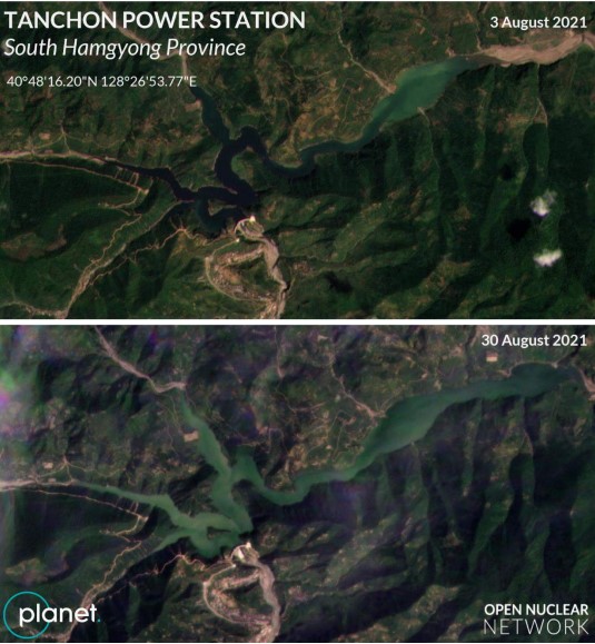
Figure 24. A comparison of the water levels at the Tanchon Power Station dam. Image © 2021 Planet Labs Inc. All Rights Reserved. Reprinted by permission
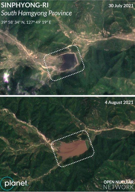
Figure 25. Significant increase in the water level at a reservoir near Sinphyong-ri, south of Hamhung. Image © 2021 Planet Labs Inc. All Rights Reserved. Reprinted by permission
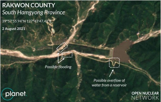
Figure 26. Water reservoir in Rakwon County, South Hamgyong Province, 2 August 2021. Image © 2021 Planet Labs Inc. All Rights Reserved. Reprinted by permission
Nuclear and Ballistic MissileRelated Facilities
No damage was observed at most facilities known to be related to the DPRK's nuclear or ballistic missile programmes. The only exception is the Tonghae Satellite Launching Ground, where some of the suspected launch control/administrative buildings and surrounding smaller buildings were flooded, but it is unclear whether these structures were damaged as a result of the flooding (Figure 27). [17]
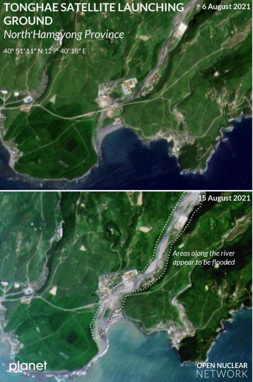
Figure 27. Flooded area at the Tonghae Satellite Launching Ground. Image © 2021 Planet Labs Inc. All Rights Reserved. Reprinted by permission
Conclusion
Heavy rainfall and flooding have caused considerable damage to many regions in the DPRK. The scale of the reported damage this year appears to be close to the damage highlighted by DPRK media in August 2020. The rainy season may continue throughout September as it did in 2020. A prolonged period of heavy rainfall and flooding could further weaken the soil, which could cause further damage to roads, railways, riversides and agricultural areas. To prevent additional damage, further measures would be needed for the DPRK to ensure the integrity of these structures and areas.
On the other hand, there are some regions which have experienced sustained low levels of precipitation, including Pyonggang County in Kangwon Province, where drought has been continuing since mid-July.
In summary, the DPRK has suffered from extreme weather conditions throughout August 2021 and continues to do so. While some regions suffered from drought, others suffered from heavy rainfall and flooding. The extreme weather conditions are expected to impose significant economic and social costs on the DPRK.
The DPRK leadership will need to invest a considerable amount of time and energy in reconstruction and damage prevention and mitigation until the rainy season concludes in the fall.
[1] 주체 110(2021)년 8월 5일 중앙텔레비죤 20시보도 [Juche 110 (2021) August 5, KCTV 20:00 Report], KCTV, 5 August 2021, aired at 20:13-20:20, available on YouTube at: https://www.youtube.com/watch?v=SGwTP4LSWVM
[2] Some regions still suffer from a low precipitation level, including Pyonggang County in Kangwon Province.
[3] The 19 DPRK monitoring stations are located at the following sites: Sebong (North Hamgyong Province), Chongjin (North Hamgyong Province), Samjiyon (Ryanggang Province), Pungsan (Ryanggang Province), Sinpo (South Hamgyong Province), Hamhung (South Hamgyong Province), Changjin (South Hamgyong Province), Changjon (Kangwon Province), Wonsan (Kangwon Province), Pyonggang (Kangwon Province), Kanggye (Chagang Province), Huichon (Chagang Province), Yangdok (South Pyongan Province), Nampo (South Pyongan Province), Anju (South Pyongan Province), Supung Dam (North Pyongan Province), Kuson (North Pyongan Province), Ryongyon (South Hwanghae Province), Kaesong (Kaesong Industrial Region). The Chinese monitoring stations are located in Changbai County, Linjiang City, Ji'An City and Dandong.
[4] World Meteorological Organization (WMO) Station Explorer, available at: https://gis.ipad.fas.usda.gov/WmoStationExplorer/
[5] Colin Zwirko first found flooding to have occurred in the early days of August 2021 in small towns along major rivers in the North and South Hamgyong Provinces. See, Colin Zwirko, Crises mount in North Korea as major flooding follows drought, food shortages: Satellite imagery reveals flooded homes and broken bridges from severe August rains, NK News, 4 August 2021, available at: https://www.nknews.org/2021/08/crises-mount-in-north-korea-as-majorflooding-follows-drought-food-shortages/
[6] All-out Campaign for Recovery from Flood Damage Launched in South Hamgyong Province, KCNA, 10 August 2021; Promotion of the disaster recovery project in South Hamgyong Province/Support project for the people in the affected area, Chosun Shinbo Pyongyang Branch, 11 August 2021; DPRK Premier Inspects Flood-hit Areas in South Hamgyong Province, KCNA, 12 August 2021; Sincere Aid Rendered to Flood Victims in DPRK, KCNA, 13 August 2021; Actively promote road restoration work with the united power of the military and citizens, Rodong Sinmun, 13 August 2021; Innovation in embankment construction, Rodong Sinmun, 17 August 2021; The more difficult time, the closer to the people, Rodong Sinmun, 17 August 2021; The warmth of the military people, Rodong Sinmun, 17 August 2021; and Restorations of communication networks in dozens of rural areas and post offices, Rodong Sinmun, 18 August 2021
[7] 주체110(2021)년 8월 5일 중앙텔레비죤 20시보도 [Juche 110 (2021) August 5, KCTV 20:00 Report], KCTV, 5 August 2021, aired at 20:13-20:20, available at: https://www.youtube.com/watch?v=SGwTP4LSWVM
[8] Supreme Leader Kim Jong Un Inspects Flood-Damaged Area in North Hwanghae Province, KCNA, 7 August 2020; 주체110(2021)년 8월 5일 중앙텔레비죤 20시보도 [Juche 110 (2021) August 5, KCTV 20:00 Report], KCTV, 5 August 2021, aired at 20:13-20:20, available at: https://www.youtube.com/watch?v=SGwTP4LSWVM
[9] 3rd Plenary Meeting of 8th Central Committee of the WPK Opens, KCNA, 16 June 2021
[10] The colour of the water in an estuary changes after heavy rainfall and severe flooding.
[11] 당중앙의 두리에 굳게 뭉친 일심단결, 군민일치의 위력 떨치며 피해복구전투를 힘있게 다그친다 [One-hearted unity firmly united around the centre of the Party, and the power of military-people unity is exerted, and the battle for restoration of damage is vigorously accelerated], Rodong Sinmun, 9 August 2021, available at: http://www.rodong.rep.kp/ko/index.php?strPageID=SF01_02_01&newsID=2021-08-09- 0002
[12] Ibid.
[13] This discovery was first published by NK News: Colin Zwirko, Crises mount in North Korea as major flooding follows drought, food shortages: Satellite imagery reveals flooded homes and broken bridges from severe August rains, NK News, 4 August 2021, available at: https://www.nknews.org/2021/08/crises-mount-in-north-korea-as-major-flooding-followsdrought-food-shortages/
[14] Ibid.
[15] At Komusan Cement Factory, Rodong Sinmun, 11 May 2019
[16] This discovery was first published by NK News: Colin Zwirko, North Korean rocket launch site, villages flooded as state media silent, NK News, 20 August 2021, available at: https://www.nknews.org/2021/08/north-korean-rocket-launch-site-villages-flooded-asstate-media-silent/
[17] This discovery was first published by NK News: Colin Zwirko, North Korean rocket launch site, villages flooded as state media silent, NK News, 20 August 2021, available at: https://www.nknews.org/2021/08/north-korean-rocket-launch-site-villages-flooded-asstate-media-silent/